If the southwestern and central portions of Mexico are in your travel plans over the next few days, you may want to consider delaying your travel — or, at least, keep yourself updated as to the latest information pertaining to the weather.
Hurricane Patricia is currently a Category 5 storm on the Saffir-Simpson Hurricane Wind Scale — which is the highest rank on that scale, with sustained wind speeds of 185 miles per hour — located approximately 185 miles almost due south of the coastal city of Manzanillo; and it will most likely retain its strength at the time of landfall currently expected for Friday evening, October 23, 2015 just northwest of the city.
“Catastrophic” is the word repeatedly used by meteorologists in describing the potential aftermath of the landfall of the hurricane, as this is a hurricane of historic proportions because it is the strongest hurricane in the eastern Pacific Ocean on record — ever…
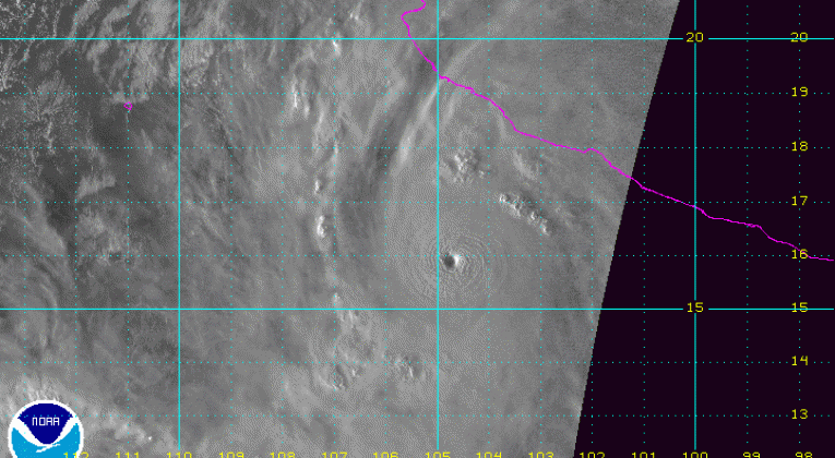
…and the satellite image shown at the top of this article — the pink line representing the southwestern coast of Mexico — shows a classic textbook example of a well-defined round “eye”, which is indicative of the strength of this storm. That “eye” is the center of the hurricane and where the lowest atmospheric pressure is located — and a recorded pressure of 892 millibars is considered significantly low for a hurricane. Hurricanes are usually stronger as the recorded pressure in the center of the storm is lower.
As a comparison, the lowest recorded pressure of Hurricane Andrew in 1992 was 922 millibars with maximum sustained winds of 175 miles per hour; while the lowest recorded pressure of Hurricane Katrina in 2005 was 902 millibars with maximum sustained winds of 174 miles per hour. Hurricane Patricia is not a storm to be taken lightly.
In addition to Manzanillo, other affected cities and towns include Puerto Vallarta and Guadalajara — and, to a far lesser extent — Mexico City. Significant flooding from several inches of rain is the greatest concern; although strong winds, mudslides, high waves and pounding surf are expected along the southwestern coast of Mexico.
Monterrey — in the northeastern part of Mexico not all that far from the southern border of Texas — is expected to experience moderate flooding; but by that time, the storm will have weakened substantially due to it crossing the Sierra Madre del Sur Mountains. Still, areas of the states of Texas and Oklahoma could experience some significant flooding once the tropical system crosses the border into the United States.
Keep up to date on the latest information pertaining to this tropical system which may adversely affect your travel plans. Better yet, you may want to consider postponing or canceling your trip, as it might be a better option — no matter which mode of travel you plan on taking.
If you have a flight scheduled, your flight could be delayed or canceled — and you may be eligible for a waiver of a fee to change your itinerary. If you are driving in any of these areas, watch out for deteriorating weather conditions and traffic problems.
Consider contacting your airline or transportation provider for the latest information pertaining to your travels as this situation progresses. Travel advisories— such as this one by Delta Air Lines for Puerto Vallarta, with additional ones possible — may be issued where you can change or cancel your itinerary and possibly receive a full refund where applicable with no fees and at no cost.
Hurricane Patricia is a serious storm with which not to take chances. Please be as prepared as possible — and travel safely.
Source of satellite image: the National Hurricane Center of the National Weather Service of the National Oceanic and Atmospheric Administration of the United States.


[…] http://insideflyerus.wpengine.com/2015/10/travel-alert-hurricane-patricia-threatens-southwestern-mexico-with-ca… […]